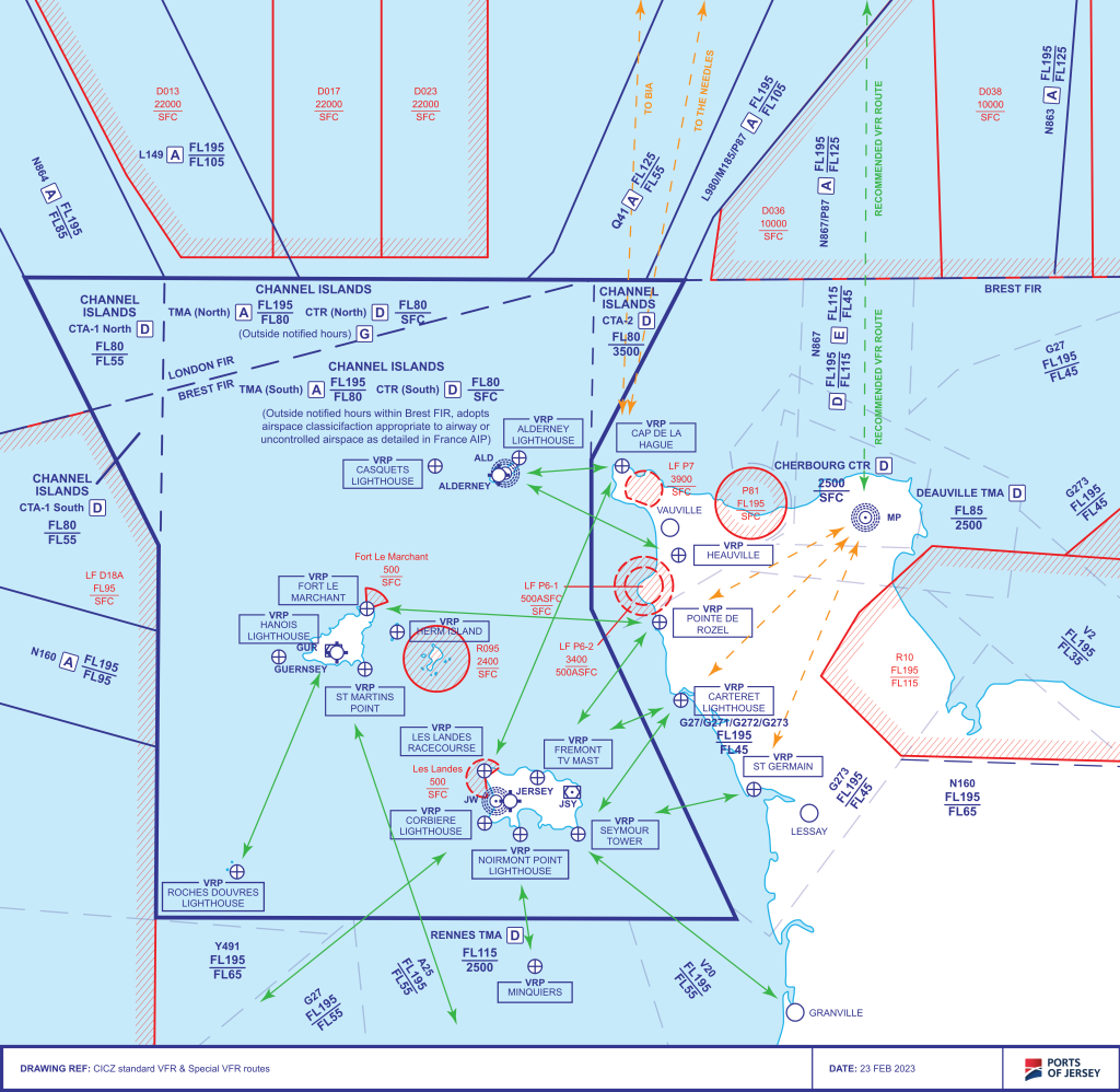
In order to reduce the risk of delay, re-routing or extensive holding; flights operating on a VFR or Special VFR clearance within the Channel Islands Control Zone (CTR) can expect to be issued a clearance based on recommended routes between notified Visual Reference Points.
These routes have been established in order to keep VFR traffic clear of any restricted areas, de-conflicted from IFR Departures and Arrival tracks and Inter-Island routes.
STANDARD VFR ROUTES

Standard routes established between Alderney and French coast:
Standard Routes have been established between:
- Alderney and Cap de la Hague (CDLH)
- Alderney and Heauville (HVLLE)
Other route availability:
Clearance is normally available to route between Alderney and the North or Western Zone boundary (50N/3W) subject to the status of any Danger Area Activity.
Standard routes established between Guernsey and French coast:
Standard Routes have been established between:
- Fort Le Marchant (FORT) Guernsey and Pointe de Rozel (ROZEL)
- Guernsey and Roches Douvres Lighthouse (RDL)
- Guernsey and 49N direction Dinard (DIN)
Other route availability:
Clearance is normally available to route between Guernsey and the North or Western Zone boundary (50N/3W) subject to the status of any Danger Area Activity.
Standard routes established for Jersey:
Standard Routes have been established between:
- Les Landes Racecourse (LLR) or Fremont TV Mast (FREM) and Cap de la Hague (CDLH)
- Les Landes Racecourse (LLR) or Fremont TV Mast (FREM) and Pointe de Rozel (ROZEL)
- Les Landes Racecourse (LLR) or Fremont TV Mast (FREM) and Carteret lighthouse (CART)
- Seymour Tower (SEYT) and Carteret lighthouse (CART)
- Seymour Tower (SEYT) and St. Germain (GERM)
- Seymour Tower (SEYT) direction Granville (GV)
- Jersey and Minquies (MINQ)
- Jersey and Saint Brieuc (SB)
Other route availability:
Clearance is normally available to route between St Brieuc (SB) and Corbiere Lighthouse (CORB)
Clearance is normally available between Jersey, Guernsey (GUR) and 50N/3W in the direction of Berry Head (BHD) although during periods of high traffic workload pilots may experience extensive track deviations in order to route around or over airspace delegated to Guernsey Approach Control.
Standard INTER-ISLAND Routes:
Standard Routes have been established between the islands as follows:
- Jersey to Guernsey – initial clearance limit will be St. Martins Point
- Guernsey to Jersey – initial clearance limit will be Les Landes Racecourse (LLR)
- Alderney to Jersey – initial clearance limit of Les Landes Racecourse (LLR)
- Jersey to Alderney (Runway 26) – clearance limit will be Alderney Lighthouse (AL)
- Jersey to Alderney (Runway 08) – clearance limit will be Casquets Lighthouse (CASQ) [CAUTION R095]
Pilots remain responsible for obtaining information regarding the status of any Danger Area Activity and/or for requesting a Danger Area Crossing Service from the appropriate Air Traffic Service Provider. Pre-flight information regarding the status of the Danger Areas north of the CICZ may be obtained from Plymouth Operations Tel:+44 (0)1752 557550. Danger Area Crossing Service DACS: Plymouth Military on 124.150 MHz when open.
The restricted areas at Cap de la Hague and Cap Flamenville are strictly policed by the French Military and pilots should exercise due diligence when routing in the vicinity of these areas.
Visual Reference Points:
| Visual Reference Point Name | Position | VOR/DME fix JSY | VOR/DME fix GUR | VOR/DME fix DIN | Acceptable VFR flight plan abbreviation* |
|---|---|---|---|---|---|
| Alderney Lighthouse | 494345N 0020951W | 045°/24.5nm | AL | ||
| Cap de la Hague | 494300N 0015600W | 011°/30nm | 061°/31nm | CDLH | |
| Carteret Lighthouse | 492224N 0014824W | 048°/13nm | 100°/31nm | CART | |
| Casquets Lighthouse | 494320N 0022237W | 340°/33nm | 030°/19nm | CASQ | |
| Corbiere Lighthouse | 491047N 0021500W | 256°/8nm | 141°/21nm | 352°/36nm | CORB |
| Fort Le Marchant | 493032N 0023107W | 039°/5.5nm | FORT | ||
| Fremont TV Mast (812ft amsl) | 491506N 0020753W | 301°/3nm | 124°/21nm | FREM | |
| Hanois Lighthouse | 492606N 0024209W | 269°/3.9nm | HAN | ||
| Heauville | 493459N 0014807W | 026°/24nm | 077°/33nm | HVLLE | |
| Herm Island | 492818N 0022655W | 072°/6.4nm | HERM | ||
| Granville Airport | 485258N 0013350W | 139°/28nm | 052°/27nm | GV | |
| Roche Douvres Lighthouse | 490615N 0024848W | 260°/31nm | 206°/21nm | 320°/43nm | RDL |
| Minquiers | 485800N 0020800W | 195°/16nm | 149°/34nm | 358°/22nm | MINQ |
| Noirmont Point Lighthouse | 490955N 0021005W | 238°/6nm | 354°/35nm | NMNT | |
| Les Landes Racecourse | 491511N 0021445W | 285°/8nm | 128°/18nm | LLR | |
| St. Germain | 491400N 0013800W | 012°/30nm | 012°/30nm | 028°/43nm | GERM |
| Seymour Tower | 490927N 0020028W | 158°/4nm | 125°/28.8nm | 005°/34.4nm | SEYT |
| St. Martins Point | 492518N 0023142W | 109°/3.1nm | 341°/53nm | SMP | |
| Pointe de Rozel | 492859N 0015059W | 029°/18nm | 087°/30nm | ROZEL |
They may not be recognised by any other Air Traffic Control unit or Service Provider in which case normal ICAO Flight Plan
route identifiers must be used.
